This summer, I repeated the route and doubled it by exploring further along the TCAT past Sudbury, looping over to the fantastic historic town of Cobalt at Lake Temiskaming and rejoining my original route at Mattawa. The theme this time was to spend more time exploring the many ghost towns and old mines along the way, and to get a better sense of the local history. The map below shows my planned route, but--and as you'll see later--some of it proved impassable and I had to go around.

Altogether this year's ride took six long days, four of which consisted of torrential downpours, soaked clothing, and mud. Lots of alone-time in the helmet, absorbing the vast expanse of our beautiful and rugged province, talking to myself, and contemplating the merits of maybe getting a slightly larger motorcycle for future adventures. But my bulletproof WR250R was once again a total champ and got me through unscathed.
Unfortunately, whereas last year my phone died after day one and I could no longer take pictures, this year it was the turn of my new Garmin 64st to crap out, which happened on the last day with the result that I lost all my trip data. This is my third such Garmin in just over year. The previous 64st (which was replaced under warranty) and before that a 60cs all died on their own for random reasons. Without a reliable guide to the turnoffs, on the last day I was forced to abandon the interesting backcountry trails taking me home to Almonte from Mattawa that I had followed last year.
Overall it was a fantastic ride with a good mix of technical trails, stunning scenery, historic detours, and a total mining geek-fest in Cobalt. Highly recommended for small- to mid-sized adventure bikes with at least 250km range and ideally 350km range (in my case, achieved with a 12L tank and 4L RotoPax). You should also spring for a trail pass from TheTrail.ca, since the funds help the Eastern Ontario Trail Association access and maintain these beautiful locations to ride.
My bike set-up and travel gear was essentially the same as last year: lightweight, camping-oriented, and with tools, spare tubes, and minimal food and clothing. However, whereas last year I rode on full knobbies, this year I rode on Mitas E-09 50/50 tires in arguably worse trail conditions, yet they performed very well. Given the long stretches of unavoidable pavement this time around, I actually preferred not being on knobbies. Another key change was having my suspension re-valved last fall, and installing a stiffer shock spring. This made all the difference in the sand, whoops, and ruts--no major control issues at all despite being a loaded bike.

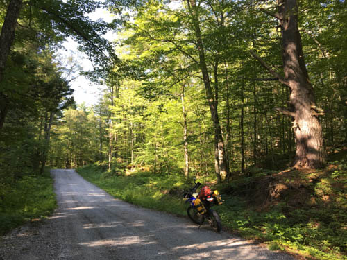
My route out of Almonte followed my local trail sauce before connecting with the TCAT. Lots of dirt roads with some roller-coasters thrown in.

The section north of Dalhousie Lake is rugged and beautiful - well worth a day ride from the Ottawa area.
Here's typical evidence that today's hamlets were much more vibrant (and populous) communities a hundred years ago:

On Buckshot Lake Rd., my route was supposed to turn west onto Brooks Lake Rd. as dirt way through to Highway 41, but this proved to be a dead-end not far past a lonely homesteader's cabin. The only sign of life on this road was, improbably, an immaculate new Mercedes SUV that was crawling over the boulders and steep hills behind me, presumably to access the lake at the dead-end. Yee-haw. Last year I tried a different route through this section, but I got stumped then too. Many years ago I did a mountain bike ride through this area as part of a 24-hour adventure race, but I have yet to rediscover that route which wound over to the top of Mazinaw Lake.

No choice but to turn back to Buckshot Rd. and follow it around through Vennachar to Ferguson Corners. From there, the route on Smith Lake Road was a long, beautiful ride on sandy dirt with a few rough and wet sections and vestiges of pioneer cabins now as hunt camps and shelters. This is a highly recommended section to ride on almost any bike, also within reach of a day-trip from Ottawa.


One of the notable stops along this remote section was the ghost town of the Bessemer Iron Mine (1899-1914), which required a northern detour to reach a former rail bed to the mine. This is well worth a look although the mine site proper is now closed off on private property. A great video of the mine site on the private property is available here.
Here's the right turn onto the former rail bed to Bessemer:

Before long, you reach the site where a town of about 300 miners and their families once toiled for a better future. Just to the left of where my bike is parked you can see where the old rail bed runs into a rock cut in the woods, and from there to the mine head as shown in an old photo below.

This same location on the road is actually the former "downtown" area of the community, with boarding houses, shops, post office, etc. On the right (south) side of the road, hidden in the trees, is an intriguing hole blasted out of the rock, with what appears to have been stonework around the top. A book by Dave Hanes about the mine's history (details below) suggests this feature was built as a cold storage to serve a large log boarding house, the east end of which was located about 40 feet west of the hole.

Just east the blasted hole and on the same side of the road is a large and impressive stone foundation. Hanes's book records an interview with one of the local old-timers who worked at the mine, who said the old log boarding house had no foundation and was built right on the ground (indeed, I saw was no obvious evidence of a foundation beside the hole/root cellar). This stone foundation was built for a hotel and never finished: "never had a board on it" said the old-timer. There are apparently some other foundations in the general area, but I didn't have much time to explore.


This small hunting cottage was, I think, originally the company store for the mine.

A small stream drains from Mullet Lake (seen below) into Little Mullet Lake (where most of the mining occurred). Here's where the stream crosses under a culvert in the trail. A sawmill was located here. A diver who explored the lake bottom near this site found the remains of a log sleigh and team of horses that presumably fell through the ice back when the mine was running.

According to an old site map, the Bessemer school house was located on the left shoreline of Little Mullet Lake as seen in this picture from the road/railbed.

For more detailed information about the history of the Bessemer Mine, Dave Hanes's book "Iron Mining at Bessemer 1899-1914, The Hand of Father Time" (ISBN 0-88954-424-7) is an excellent resource. Hanes conducted extensive research at the site and interviewed key old-timers in the area--the stories are entertaining and provide a fascinating perspective on a era of early European settlement in Ontario that has all but disappeared into the bush. You can order the book from Darlene at the bookstore in Cobalt (more on that later). Here's a view of the main mine workings, I believe from a perspective near the end of the overgrown rail line through the rock cut shown in a picture above.

The overgrowth and bugs proved too obstinate for me to explore here further, so I carried on with my main adventure and headed on to Bancroft.
After Bancroft comes one of the most challenging sections of trail on the whole route: Pencil Lake Road. It's a heavily rutted, rocky ATV/Jeep trail that nevertheless is a riding highlight of the whole route. Last year I followed this road to its end near Irondale (another ghost town), but there was one particularly rough section with a deep swamp that required bypassing via a steep climb and descent over a large knoll of bedrock. Given the torrential rains this year, my slower progress overall, and the likelihood of much more standing water on the section of the trail, I decided to avoid the risk in favour of investigating an alternate route. The TCAT showed a detour from Pencil Lake Rd. north onto Hadlington Rd., which in theory should've avoided the need to ride through Pencil Lake Rd's long sections of standing water. Indeed, the bypass started out just fine:

Then it quickly devolved into hellish mud pits which I was barely able to ride with my 50/50 tires, despite a relatively light bike. Fortunately I had thought to bring a handsaw with me, so I was able to remove some strategic branches and pass beside several of these holes. However, I got stuck in a few holes that were slimy, sucky, deep mud (2 feet deep in some places). It was pretty miserable trying to pull myself out while of course a storm arose and raged around me. I absolutely do not recommend this alternate route for larger bikes. It was one hole after another for a few kilometers, few of which offered a way around that could be navigated with bags on. Definitely one of the worst (or, should I say "character-building") sections on the whole trip. In retrospect I would take Pencil Lake Rd. all the way again, because if memory serves me, much of the trail had a rocky base and lacked this type of silty mud.

Suwan's Thai Restaurant in Minden made a welcome and tasty (but slow) dinner stop before heading north towards my first camp near Huntsville. The owner and his Thai wife split their time between Minden and Thailand, and have collected all manner of ephemera which is displayed (and for sale) in their popular restaurant.

Here's a view of the cabin, which my parents bought from a close family friend whose father had built (and stocked) the cabin around 1920. No electricity, no water. Still rustic like the pioneer cabins back then.

Part 2 covers my progress further along the TCAT through the forests, ghost towns, and sandy glacial till that stretch north of Huntsville well up past Sudbury. New challenges, new things to see, and finally some pictures of the route since I wasn't able to get any last year!
Great stuff! Do you have a YouTube or Instagram?
ReplyDeleteSorry, no--and a little embarrassing considering I used to be in the marcom biz. Barely enough time to ride, never mind edit vids and keep this blog up to date!
ReplyDelete